May 4, 2012
Up to the Mountain Lily (Ware) Mine with John McLean and Ben Castillo to meet up with Casey Jones to do some reconnaissance on the terrain and positioning of the pegmatite on a new plot of land at the northern edge of San Diego County.
The drive up takes us east of Fallbrook, out Highway 76 past many casinos, and around Lake Henshaw, which currently is at a very low level. For those who know the lake, Monkey Island is not even an island anymore—it’s just a hill on the side of the lake.
Winding up and around the back side of Palomar mountain on Highway 79, the road up to the mine is semi-paved, narrow and steep. John and Casey look out for critical points in the road that will be difficult for the excavator to make it up.
View to the north with the old structure in the foreground.
Click to enlarge. (Photo: Jason Stephenson)
Once on top we all check out the old broken-down structure that sits to the south end of the property, looking out at a beautiful view of the valley and Lake Henshaw far below. We make our way over to the north end of the property where the pegmatite comes close to the surface. A washed out edge and sink hole mark where the original tunnel was. Now all that’s left is an opening barely big enough to crawl in.
I decided to wiggle down in for a closer look but once I was a body length in I realized it wasn’t safe. Unstable, thick mud shifted below my feet and the cavern was at a steep angle with minimal room to move around. To top it off, an angry bee started dive bombing me, as if a signal to get the hell out of there. I did, immediately, but the bee wasn’t done with me; he attacked me for another 20 yards or so until I could lose him.
A look up the bluff toward the original glory hole, and the thick bushes which were heavily bee infested.
Click to enlarge. (Photo: Jason Stephenson)
John McLean surveys the bluff for signs where the pegmatite surfaces.
Click to enlarge. (Photo: Jason Stephenson)
John and Casey surveyed the lay of the land and figured out a plan of attack to uncover the near-horizontal pegmatite. The end of the pegmatite to the north is exposed on a 30-foot bluff. At the bottom of the bluff is a level edge that then drops off again down the mountain. The plan is to basically remove the bluff face incrementally and pile the earth back at the level plane and create a big berm, all the while sorting though the rich pegmatite. Seems easy enough, but time will tell as we begin to move some dirt around.
John McLean and Ben Castillo look over the mineral samples collected throughout the day. Notice the weathered bluff in the background where the pegmatite lies in wait.
Click to enlarge. (Photo: Jason Stephenson)
We all found traces of blue and green tourmaline even in the heavily picked-through tailing, signs of a rich vein above. We turned over every quartz crystal too, just to make sure it wasn’t topaz, which is another gem we’ll be on the lookout for up there.
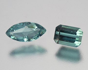
Indicolites from the Mountain Lily Mine: marquise 0.46 ct and the emerald cut 0.56 ct. A gift from Jeff Swanger of the Ocean View Mine.
(Photo: Mia Dixon)