![]()
With Pala Presents, we offer selections from the library of Pala International’s Bill Larson, who shares with us some of the wealth of information in the realm of minerals and mineralogy.
 |
Gem- and Lithium-Bearing Pegmatites of the Pala District, Part 4
By
Richard H. Jahns
and
Lauren A. Wright
Prepared in Cooperation With the
United States Geological Survey, June 1951
Contents
PHYSICAL FEATURES
HISTORICAL SKETCH
GEOLOGY
PEGMATITES
ECONOMIC FEATURES OF THE PEGMATITE MINERALS
MINING
DESCRIPTIONS OF SELECTED MINES
Tourmaline King (Wilke, Schuyler) mine
DESCRIPTIONS OF SELECTED MINES
Tourmaline King (Wilke, Schuyler) Mine
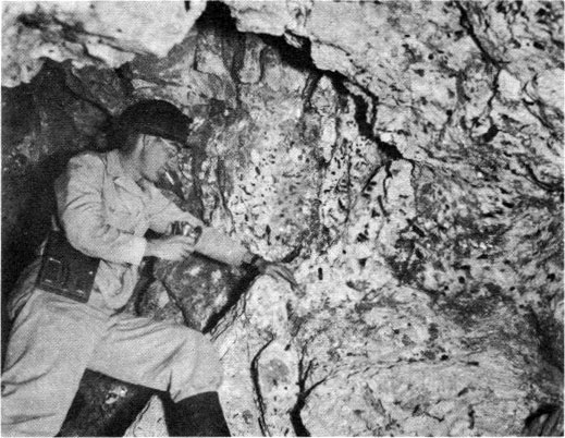
The Tourmaline King mine is high on the northwest slope of Queen Mountain, due north of Pala (pl. 2). It can be reached by an old wagon road from the Stewart road to the south, or by trail from the abandoned site of Salmons City to the east. The surface workings lie at altitudes ranging from 1500 to 1700 feet, and comprise several small, irregular cuts for 450 feet along the trace of a pegmatite dike that trends northwest down the very steep slope. The dike has been mined extensively underground, and interconnected drifts, inclines, and irregular rooms constitute more than 1200 feet of tunnel. The mine was opened by F. B. Schuyler of San Diego in 1903, and during the early years of its operation yielded much gem tourmaline of exceptional quality. It was later purchased by R. M. Wilke of Palo Alto, who carried on a very thorough program of exploration but obtained only small returns.
The pegmatite dike ranges in thickness from a knife edge to about 16 feet, and its average thickness appears to be 8 feet or slightly less. It strikes north and dips 25° to nearly 40° W., and has an average dip of about 32°. In most of the mine workings the country rock is gabbro, but in the Canyon cut and other lower workings it is thinly foliated feldspathic quartzite and light-gray quartz-mica schist. As shown in plate 3, the dike appears to cut across a major contact between gabbro on the southeast and quartzite with small sill-like masses of gabbro on the northwest. This contact trends northeast in the immediate vicinity of the mine, but to the south it is more complex, and is marked by septa of gabbro that extend southward and westward into the quartzite. In most places the foliation and bedding in the metamorphic rocks trend east-northeast to northeast and dip steeply north-northwest to northwest.
The dike is marked by many rolls, most of which have amplitudes of 2 to 5 feet. One of them is well exposed at the extreme southeast end of the surface workings. Many of the rolls are represented merely by changes in dip, generally a flattening of 5° to 10°. The dike consists chiefly of coarse-grained graphic granite with subordinate albite and muscovite, although much of its footwall part is a fine-grained, sugary, albite-rich pegmatite with crudely developed planar structure. The pegmatite does not closely resemble the typical sharply layered line rock. In most places, the hanging-wall graphic granite can be traced downward into much coarser-grained graphic granite, and thence locally into thin, lenticular masses of quartz-euhedral perthite pegmatite. In a very few places, segments of a quartz core are exposed. The coarse-grained inner units form only a very small part of the pegmatite as a whole, probably less than 5 percent.
Much of the graphic granite contains abundant muscovite and biotite, chiefly as radial aggregates of rather coarse flakes and plates. Garnet is exceptionally abundant, and forms wine-red to salmon-colored euhedral crystals that locally constitute 15 percent of the rock. Many of these crystals are as much as 2 inches in diameter. Other garnet masses are subgraphically intergrown with quartz, and still others are surrounded by or intergrown with schorl. Here and there in the graphic granite, especially within a few feet of the hanging wall in the upper part of the mine workings, are concentrations of coarse lepidolite, pink tourmaline, and other typical pocket minerals. Many of them are in places formerly occupied by parts of graphic-granite crystals. Other masses of lepidolite, albite, and tourmaline fill fractures in the graphic granite.
The pocket-bearing part of the dike is very discontinuous and poorly defined. Most of the characteristic minerals are scattered as irregular bunches or knots through the coarse graphic granite and quartz- or perthite-rich pegmatite of the inner zones.
The only notable concentration of tourmaline and lepidolite was encountered and subsequently mined out in the workings immediately south of the Main cut. It occurred in a discoidal body of typical pocket pegmatite that was several tens of feet long, 1 foot to 6 feet thick, and at least 30 feet in maximum down-dip extent. It is said that this mass yielded the bulk of saleable tourmaline obtained from the deposit.
The interior parts of the dike are marked in many places by concentrations of coarse schorl, opaque pink tourmaline, coarse cleavelandite, and irregular masses of fine-grained lepidolite. The dumps contain abundant pocket material, and attractive specimens are still obtainable in several places. Many rosettes of coarse cleavelandite are coated with aggregates of lepidolite flakes and crystals, and extending from their surfaces are pencil-like crystals of rubellite. Most of the tourmaline appears to be slightly altered, and is opaque. Some aggregates of prismatic rubellite crystals occur in lepidolite, and resemble the material so abundant in the south part of the Stewart dike.
The deposit appears to have been thoroughly prospected, and indeed, there is much to suggest that the bulk of the pegmatite has been mined out. In many places, particularly in the inner parts of the upper underground workings, the keel of the dike evidently has been encountered. It fingers out into long, thin, subparallel septa that extend into the gabbroic country rock. Except for the one very large concentration of gem minerals encountered in the workings from the Main cut, the dike has yielded little commercial material, and it does not appear to offer great promise for future development.
Tourmaline Queen Mine
The workings of the Tourmaline Queen mine are high on the east slope of Queen Mountain, about 1500 feet east-southeast of the Tourmaline King mine (pl. 2). They are at an altitude of about 1600 feet and are best reached over a steep but well-conditioned trail that rises west-northwestward from the valley of Salmons Creek at the site of Salmons City. The mine is in the north part of a continuous pegmatite dike that is at least 3000 feet long.
The northern part of the pegmatite dike, where several masses of milky white quartz appeared at the outcrop, was first located in 1903 as a quartz claim by F. A. Salmons and associates of Pala. Exploratory work soon revealed lepidolite, pink, blue, and green tourmaline, and other typical pocket minerals, and the mine ultimately became the leading producer of gem tourmaline in the district. It was operated chiefly during the period 1904–14, and has been worked only intermittently since that time. It is now owned by the F. A. Salmons estate, and is administered by Monta J. Moore of Pala. A little development and assessment work during recent years has led to recovery of coarse crystals of quartz and deep-blue tourmaline.
The principal mine openings comprise two benchlike cuts along the trace of the pegmatite and extensive underground workings that were driven from the north, or upper cut. These workings consist of inclines, irregular drifts, and numerous low rooms, many of which are interconnected. In general they occupy an area 150 feet long, as measured along the strike of the pegmatite, and 80 to 100 feet wide. Not all are accessible as some of them have been backfilled and others are blocked by caved ground. In particular, the Main adit or incline is completely filled at its portal by large blocks that have slumped from the face of the open cut. At least one incline or irregular sloping room extends down the dip of the dike from the southern, or smaller cut, but it is no longer accessible. It appears to have been filled in part by caved material and in part by debris washed in during periods of heavy rain.
The Main, or upper open cut is about 130 feet long, 40 to 50 feet wide, and nearly 40 feet in maximum depth. The hanging-wall contact of the pegmatite dike is very well exposed in this opening, but the lower parts of the pegmatite are concealed in most places by a thick mantle of slumped material. The dike trends north and dips 10° to 30° W. in coarse-grained gabbro, which contains numerous septa and inclusions of platy, impure quartzite and quartz-mica schist in the mine area. Some of these are as much as 25 feet in outcrop breadth. In general they trend west to west-northwest and dip very steeply. A thin septum of partly digested quartz-mica-amphibole schist and small quartzite beds is exposed above the pegmatite in the wall of the Main cut, and a thicker mass of quartzite and schist appears near the portal of the North adit.
Both the country rock and the pegmatite dike are offset in several places along small faults, most of which trend east-northeast and dip very steeply. In general the south sides of these faults appear to have moved downward with respect to the north sides, but in only a few places does the amount of movement appear to exceed 20 feet. Shearing is well developed along the pegmatite-wallrock contacts in many places, and numerous closely spaced joints within the hanging-wall part of the dike also are parallel with these contacts.
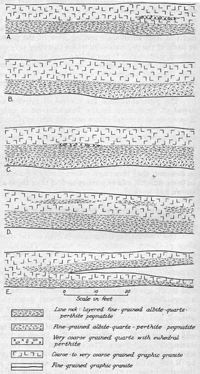 |
| Fig. 25. Idealized section of pegmatite dikes in the Pala district, showing typical relations of line rock and associated fine-grained rocks. |
Where exposed in the main surface and underground workings, the pegmatite is rather consistently layered. It ranges in thickness from about 10 feet to as much as 18 feet, but in most places it is less than 15 feet. The dike is marked by rather gentle terracelike rolls, where the dip becomes less than 10° as traced for distances of 5 to 30 feet in a down-dip direction. These terraces are separated by much more steeply dipping segments. In addition, there are several much broader, more gentle rolls whose axes trend down the dip of the dike.
From hanging wall to footwall, the dike is layered as follows:
- A selvage of muscovite-perthite-quartz-albite pegmatite ranges in thickness from a knife edge to a maximum of 6 inches. This unit is best developed in the north half of the Main cut. In many places the muscovite occurs along fractures in fine-grained graphic granite, and also along the contact between the pegmatite and the gabbro.
- Graphic granite constitutes most of the dike. It is medium- to coarse-grained, coarsening downward from the hanging-wall selvage. In many places the quartz rods tend to be oriented normal to the pegmatite-gabbro contact, but there are many exceptions. This rock is transected by fractures and ¼- to 5-inch fracture-controlled masses of muscovite and albite, with or without garnet and schorl. Most of the fractures are parallel to the hanging-wall contact of the dike. In some places in the graphic granite there are podlike to discoidal masses of closely intergrown quartz and muscovite, with some garnet and schorl; they commonly form a relatively fine-grained groundmass in a mosaic of graphic granite crystals.
- Scattered thin lenses of massive quartz with large euhedral crystals of perthite near the center of the dike are best exposed near the south end of the Main cur. Most of them are less than 10 feet long and 2 feet thick, but the original outcrop of the dike must have contained large segments of this unit.
- Typical pocket pegmatite is in and immediately beneath the segments of quartz-perthite core. This rock contains abundant quartz, with associated albite, schorl, alkali tourmaline, lepidolite, and other pocket minerals. Such material is exposed for a distance of at least 100 feet along the present trace of the dike, but at no place is it thicker than about three feet.
- Fine- to medium-grained albite-quartz-perthite pegmatite that contains plumose muscovite and local cleavelandite and schorl underlies the pocket-bearing rock. It may have been formed in part from coarse-grained graphic granite, remnants of which are scattered through it. Much of the muscovite forms thin, delicate sprays of plates 1 inch to 6 inches in maximum dimension. In a few places this rock contains as much as 10 percent schorl.
- Very crudely layered, sugary, fine- to medium-grained albite-quartz-perthite-muscovite pegmatite forms the footwall part of the dike. In some places it is in contact with massive quartz or other inner-zone pegmatite, but elsewhere it is separated from the quartz by graphic granite or by coarse-grained albite-rich pegmatite. Locally this rock contains sharply defined garnet-rich layers similar to those in the typical line rock farther east in the district, but in most places it is considerably coarser, and has little or no planar structure. The layered and unlayered rock types grade into one another, both along and across the strike of the layering. In general the more homogeneous forms of the rock are richer in fine-grained schorl than the layered types.
Much of the coarse, prismatic schorl in the lower part of the hanging-wall graphic-granite zone is clearly fracture controlled, as it extends outward from fractures or from planar positions that transect individual crystals and crystal aggregates of graphic granite. Much strip and blade biotite shows the same general relations with respect to the graphic granite and to the fine-grained footwall pegmatite (unit 6 above). Such mica is especially prominent where it lies normal to fractures, forming 1-inch to 6-inch stripes on the face of the Main cut.
Within the pocket-bearing parts of the dike, some of the coarser crystals of green muscovite are rimmed by pink to lilac lepidolite. Such muscovite also contains abundant inclusions of clear green tourmaline. Sonic crystals of schorl above the pocket horizon extend downward into this unit, and most of them grade along their lengths into green, and some into pink tourmaline.
The dike splits southward, and two dikes, separated by about 3 feet of gabbro, are poorly exposed in the lower, or south cut. The upper dike consists chiefly of coarse perthite, quartz, muscovite, schorl, and widespread garnet, and is 1½- to 4-feet thick. Although this dike is not well zoned, its central part contains irregular patches and stringers of lepidolite and other pocket minerals.
The lower dike, nearly 20 feet thick, is much more sharply zoned, but does not contain abundant pocket material. About 9 feet of graphic granite forms the hanging-wall half of the pegmatite, and passes abruptly downward into fine- to medium-grained albite-quartz-perthite-muscovite pegmatite, which is crudely layered in places. This rock contains much fine-grained flake muscovite. Both muscovite and biotite are also locally abundant in the overlying graphic granite, particularly near the hanging-wall contact. In the central part of this dike are local discoidal to lenticular masses of quartz-perthite pegmatite, and along the footwalls of these masses are the only stringers of lepidolite observed in the dike. Numerous thin, highly irregular cavities occur in this central discontinuous unit, particularly along or near contacts between the perthite and quartz.
The Tourmaline Queen mine has an impressive record of production, and according to available reports, gem material was obtained from most parts of the surface and underground workings. The total output from the deposit is not known, but a series of sales of gem tourmaline amounting to $48,000 was recorded for one year. Most of this material was marketed to eastern consumers, chiefly Tiffany and Company and the American Gem and Pearl Company of New York City. Assessment work during recent years has been done in a short, gently sloping incline that lies south of the caved entrance to the old Main adit or incline. Numerous pockets were encountered during the course of this work.
It seems likely that additional pocket-bearing ground is present in the pegmatite, not only in unmined areas that are surrounded by existing workings, but in parts of the dike down dip from the limits of the present underground workings. The gem-bearing part of the dike appears to extend almost directly down the dip, with possibly a slight component to the south. Most of the pockets appear to have been concentrated along the terracelike features in the pegmatite, and if additional flattenings of dip are encountered, the possibilities for further substantial returns of gem material appear to be fairly good. The pegmatite exposed in the south cut probably docs not warrant much attention, as it is reported to become barren down the dip and to pinch out locally.
Gem Star (Loughbaugh) Mine
The Gem Star mine is in the thick Stewart dike, which crops out prominently on the east slope of Queen Mountain. It can be reached by trail from the Stewart mine to the south, from Salmons City to the north, and more directly from the road that adjoins Salmons Creek immediately to the east. The workings comprise several open cuts and appended inclines and drifts that are distributed along the pegmatite outcrop for a strike distance of about 500 feet. The mine was operated chiefly between 1905 and 1912 by a Mr. Loughbaugh, and during more recent years it has been worked intermittently by Francisco Moreno of Los Angeles. It is currently owned by Mr. Moreno. The past operations have yielded large quantities of crystal quartz and a little lepidolite and gem tourmaline.
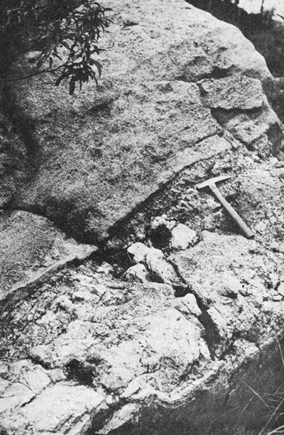 |
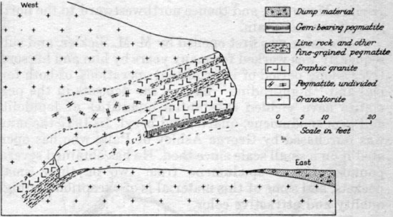
| Fig. 26. Composite pegmatite mass, east slope of Hiriart Mountain. The coarse-grained, lighter-colored pegmatite body is a sill (with some apophyses not shown in picture) in faintly layered, finer-grained albite-quartz-muscovite pegmatite. The coarser rock is rich in graphic granite, and contains local core segments of massive quartz and euhedral perthite (not in picture). |
The pegmatite is a thick composite mass that ranges in outcrop breadth from 100 feet to about 150 feet. In most places it clearly consists of three distinct dikes, which are juxtaposed without intervening masses of country rock. As traced from north to south in the mine area, however, the upper dike thins and is separated from the others by a thickening mass of gabbro. It pinches out entirely at the edge of the mine area. In most places the composite pegmatite mass trends north and dips westward at angles ranging from 20° to as much as 42°. Most of the mine workings are in the middle dike, which is 15 to 25 feet thick in most places.
The principal opening in the north end of the mine area is a large, benchlike cut, known as the Whim cut, on the crest of an eastward sloping ridge. A 70-foot incline extends westward and leads to irregular drifts. North of these workings are two smaller cuts and appended short drifts, all of which are in pegmatite. South of the Main, or Whim workings is a series of shallow scratchings along a large clifflike exposure of pegmatite, and higher on the slope are two trenches excavated in the upper pegmatite. The openings from which most of the gem production was obtained are known as the Canyon workings, and lie at the south end of the mine area (pl. 34). They consist of two open cuts, from each of which branching tunnels extend westward and southwestward. The largest, or more southerly cut yields access to drifts and short inclines at two levels.
All the mine workings are in pegmatite that is rich in coarse graphic granite. This rock grades downward through a central coarse-grained schorl-rich unit into footwall pegmatite that is distinctly finer-grained and contains abundant albite, muscovite, and schorl. Most of the pocket material encountered in the Whim and nearby workings was beneath the coarse schorl-rich unit and within thin, discontinuous segments of massive quartz and of massive quartz with giant euhedral crystals of perthite. Little but quartz crystals was obtained. The discontinuous segments of quartz core and of perthite-bearing intermediate zone are chiefly in the upper dike, but some are present also in the middle dike.
Where exposed in the vicinity of the Canyon workings, the two lower dikes are 32 to 40 feet in combined thickness. Both are markedly asymmetric, with relatively thick hanging-wall units of coarse graphic granite and much thinner footwall units of fine- to medium-grained albite-quartz-perthite-plumose muscovite pegmatite that contains local concentrations of schorl. Both pegmatite and country rock are cut by a cross fault that is well exposed along the southern edge of the open cut.
The middle dike has a thin central unit of quartz-spodumene pegmatite, with accessory lepidolite, albite, and alkali tourmaline. The unit ranges in thickness from 1 inch or 2 inches to as much as 4 feet where exposed in the underground workings, and is characterized by an abundance of pale-pink to light-gray clay minerals. These and the other pocket minerals are scattered through the thin core of quartz-spodumene pegmatite. Above this unit, the graphic granite contains very coarse-grained schorl, which forms numerous sprays or radiating groups that point downward toward the pockets.
The tourmaline in the pockets is fairly hard, although much of it is sufficiently altered to be opaque. Many clear fragments of small crystals are present in the dumps, and some clear, gem-quality crystals as much as 4 inches in diameter and 15 inches long were recovered. The chief associates of the tourmaline are crystalline pink to lavender lepidolite, smoky quartz, apple-green albite, and very rare fragments of clear spodumene. All of these minerals are fringed or surrounded by pink clay.
The pocket-bearing pegmatite is fairly continuous throughout the Canyon workings, and is well exposed in the face of the incline that extends southwestward from the northwest end of the drift. Additional material of this sort probably remains to be mined, but the gem-bearing part of the dike is so thin and contains such a low proportion of unaltered, usable tourmaline that there might well be doubt as to the possible success of future mining operations. The pegmatite exposed in the workings farther north appears to be virtually barren of commercially desirable minerals.
Stewart Mine
The Stewart mine, once the most important domestic source of lepidolite, is in the bulbous south part of the Stewart pegmatite, and lies on both sides of a prominent ridge that forms the southeastern corner of Queen Mountain (pl. 2). The pegmatite itself is traceable for half a mile along the east slope of the mountain, on which it appears as a well-defined riblike feature. The mine workings can be reached over a road that extends eastward from the Pala-Temecula road, and also over several trails that ascend the slopes to the south and east.
Approximately 18 tons of lepidolite was taken from the deposit in 1892, the first year of mining, and the output was gradually increased during the following years. A substantial annual production was maintained from 1900 to 1907, when the price of lithium salts dropped as a result of the mining of amblygonite in the Black Hills of South Dakota. Most of the large-scale operations were conducted by the American Lithia and Chemical Company of New York. The mine was virtually idle until World War I. Maximum production was attained in 1920, after which mining activities dwindled, chiefly because of the development of the Harding lepidolite deposit in northern New Mexico. The National Industrial Chemical Corporation of New York worked the deposit for two or three years prior to its shutdown in 1928, and a little small-scale mining was done by several persons in the middle 30’s. In addition to lepidolite, the output from the deposit includes some gem tourmaline and white, pink, and golden beryl. The mine is owned by Mrs. W. H. Crane of Oceanside.
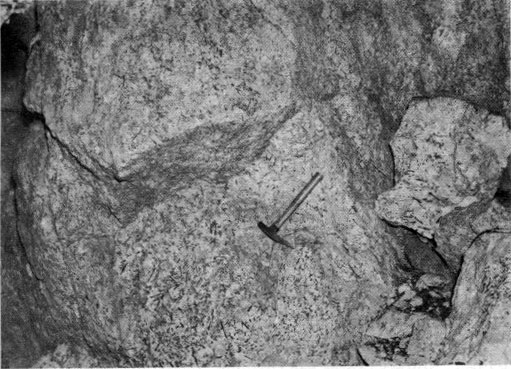 |
| Fig. 27. Thin prisms of schorl in medium-grained perthite-quartz-albite pegmatite, Gem Star mine, Queen Mountain. |
The deposit was first worked along its outcrop by open-cut methods, with progressive development of the Main cut and the much smaller North and South cuts. The largest exposed mass of lepidolite-rich pegmatite was followed westward from the Main cut by means of a curving drift, from the inner end of which a short incline was extended downward at a moderate angle. A branch adit, driven southwestward from the same cut, was connected with the Old Main adit at a point not far from its portal. Irregular stopes, some of roomlike proportions, were developed from the inner part of the Main adit, and several drifts and low rooms were extended northwestward from points near the portal of the branch adit. The North adit was driven westward into the dike from a point below and east of the North cut, and an irregular exploratory adit was driven northwestward from a point near the Alvarado workings, in the south part of the mine area.
A large mass of amblygonite was encountered in the innermost part of the workings from the Old Main adit in 1903, and soon thereafter these workings were connected with the west slope of the hill by means of the Old West adit. Several irregular stopes and rooms were excavated during the period 1902-05, as shown in plate 6. Another adit was driven northeastward from a point fairly low on the west slope of the hill during World War I, and this opening ultimately provided efficient haulage for lepidolite recovered from the deposit during the most extensive operations in the wartime and postwar period. Extending eastward and northeastward from this adit and its principal branch drift is a complex series of irregular rooms and inclines, from which large quantities of high-grade lepidolite ore were recovered. During the middle 20’s and for a short period during the middle 30’s some lepidolite was removed from the North cut and from underground workings lower and to the southwest of this opening. These workings are connected with the surface by means of a steep incline and a vertical shaft.
 |
| Fig. 28. Schorl in gem-bearing central part of Tourmaline King dike. Irregular mass of crystalline lepidolite appears dark near lower right-hand corner. This schorl, also from Queen Mountain, is coarser than that shown in figure 27. |
Other workings in the mine area, chiefly of an exploratory nature, include open cuts in the hanging-wall part of the pegmatite dike low on the west slope of the hill, several small cuts along the pegmatite outcrop on the east side of the hill, a small open cut and 50-foot tunnel south-southeast of the Main adit, and a series of irregular shallow cuts farther east. The last are known as the Alvarado workings. A long adit was driven westward in the footwall gabbro from a point beneath the main lepidolite outcrop on the east slope of the hill, but not far enough to penetrate the pegmatite dike. This work was done about 1900. It is reported that several winzes and inclines were sunk to points beneath the level of the Main adit during the middle 30’s, mainly in an effort to find extensions of the known lepidolite shoots or additional shoots. One of these lower-level workings has been broken through to the surface about 50 feet south of the Main entry.
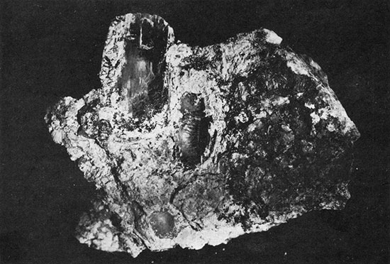 |
| Fig. 29. Fragments of gem-quality kunzite in altered crystals of spodumene, Katerina mine, Hiriart Mountain. |
Nearly all of the underground workings are in hazardous condition, owing in part to caving from extensive unsupported backs of rooms, and in part to more local collapse of badly broken rock from the back, in a few places all the way to the surface. Although the high walls of the Main cut and part of the South cut were blasted down in the early 20’s to eliminate use of the old adits, access to the underground workings was still possible through two small openings near the face of the South cut until the fall of 1948. The Main entry, which was timbered for its entire length, is partly collapsed and no longer accessible, but most of the workings with which it was connected can now be reached through the Old West adit. Many of the oldest workings, dating to the period 1900–05, have been backfilled or have been choked with slumped material. Some of the early stopes north of the large amblygonite stope near the West adit have completely collapsed, with formation of a large, quarrylike surface depression that is about 70 feet long and 25 to 35 feet wide. Nearly all of the workings connected with the North cut and the vertical shaft immediately south of this cut also are inaccessible or hazardous.
Two principal bodies of lepidolite were mined in the surface and underground workings. One of them, which extended westward from the Main cut, was about 200 feet long and 20 to 110 feet wide. Its thickness ranged from a knife edge to at least 20 feet, and was about 10 feet through much of the mined portions. This lepidolite is gray and bluish-gray to deep-purple in color, and most of it contains albite and abundant prismatic crystals of rubellite. In contrast to this material is the lepidolite typical of the other main ore body, which lies about 50 feet to the south. Most of this lepidolite rock is nearly pure, and only locally does it contain much albite and tourmaline. It is also characteristically coarser-grained and more reddish to pinkish in color than the material in the north ore body. The south ore body, which was poorly exposed in the South cut and was really discovered during the course of later, underground operations, was approximately 200 feet long, 30 to 180 feet wide, and locally as much as 18 feet thick. It was mined largely during the 20’s.
In some places the lepidolite bodies are sharply defined from the adjacent rock, and particularly from a large mass of quartz-rich pegmatite that lies between them. In many other places, notably at the north bulge of the north ore body, the lepidolite pegmatite grades into quartz-albite pegmatite with abundant stringers, lenses, and irregular stockworks of lepidolite. Much material of this sort is exposed in the walls of the North cut and the appended underground workings. Additional masses of lepidolite pegmatite, some of them satellitic to the two main masses, are in several other parts of the mine area, but most of them are relatively small.
The pegmatite body, which is at least 80 feet thick in much of the mine area, forms a steep-faced outcrop on the east side of the ridge, and appears as a very gentle to moderate dip slope of hanging-wall graphic granite over much of the west side of the hill. The contact between pegmatite and overlying gabbro passes beneath the surface in the bottom of a small canyon immediately west of the mine area. Much of the longitudinal section of the dike on the east face of the hill is obscured by dump material and other loose debris, so that the internal structure of the pegmatite is best observed underground.
As indicated in the cross-section, the pegmatite comprises many zones arranged in layers around a discontinuous quartz-spodumene zone in its central parts. The spodumene-bearing pegmatite forms lenslike masses as much as 150 feet long and 10 to 15 feet in maximum thickness. They are poorly exposed at the surface, but appear in the walls and backs of many of the underground openings. Relatively thin lenses of massive quartz overlie the quartz-spodumene core segments. This discontinuous inner intermediate zone thickens enormously beyond the edges of the core segments along the strike of the dike, and is at least 30 feet thick where exposed between the Main cut and North cut at the surface. Much more continuous is a middle intermediate zone of massive quartz with large subhedral to euhedral crystals of perthite, which appears above the massive quartz unit. In a few places this zone consists almost wholly of perthite, with only local interstitial quartz, but elsewhere the quartz is dominant or the two minerals are in nearly equal proportions. Lithium-phosphate minerals are locally abundant in this unit.
Overlying the middle intermediate zone is a 10- to 15-foot outer intermediate zone composed of coarse, blocky perthite, with some quartz, muscovite, and albite. This zone in turn is overlain in most places by the typical coarse-grained graphic granite (with subordinate albite and muscovite) of the thick hanging-wall zone. Both the graphic granite and other perthite-rich units contain much coarse, prismatic schorl, especially at distances of 15 feet to 25 feet beneath the hanging-wall contact of the dike. Thin but continuous fracture-controlled units of muscovite, albite, and green tourmaline are locally abundant.
Beneath the quartz-spodumene pegmatite of the core in some places is the inner intermediate zone of massive quartz, and elsewhere are exposed the quartz-perthite pegmatite or the outer intermediate zone of coarse, blocky perthite. Much of the footwall part of the dike, however, consists of coarse-grained albite-quartz-muscovite pegmatite and sugary, fine- to medium-grained albite-quartz-schorl-muscovite pegmatite. These rocks are not notably marked by any planar structure.
Most of the lepidolite-rich pegmatite is in the footwall parts of the quartz-spodumene core, and may have been formed largely at the expense of this unit, remnants of which occur above and between the lepidolite lenses. Flanking the lenses themselves—and grading into them— are many masses of pegmatite that contain stringers and irregular networks of lepidolite.
The relations among the zones in the hanging-wall part of the pegmatite are somewhat complicated in places by at least one other, much thinner, juxtaposed dike. This dike also is zoned, but its core appears to he quartz-perthite pegmatite analogous to the middle intermediate zone of the main dike. The two dikes split as traced to the south, although in most areas the upper one has been removed by erosion. The main dike itself splits in the vicinity of the Alvarado workings. One prong tapers out abruptly, but the other extends for some distance southeastward down the ridge beyond the workings.
No pegmatite is exposed at the surface south of the mine area, but the results of some diamond drilling done in 1903 suggest that pegmatite is present at depth. Too little is known of the relations in the few underground workings beneath the level of the Main adit to permit an estimate of the shape of the dike in a down-dip direction. Several reports concerning the old workings indicate that a few septa of gabbro were encountered during the early stages of mining. Perhaps some of them represent screens between individual pegmatite dikes, particularly where they were near the hanging-wall parts of the main composite mass.
The large bodies of lepidolite-rich pegmatite are along or near a marked benchlike roll in the dike. In most parts of the mine area, this terrace lay between the relatively steeply dipping part of the pegmatite at the outcrop and another relatively steeply dipping segment in the lowermost part of the mine. Most of the lepidolite-rich masses taper out, or become markedly discontinuous as traced down their dips into this more steeply dipping part of the dike. Other large lenses of lepidolite-rich pegmatite may well be present in the dike, either north of the extensively stoped block of ground, or farther west and down the dip of the dike. The chances for such lenses in a down-dip direction probably would be enhanced materially if the steeply dipping segment of the dike in the vicinity of the lowermost mine workings should flatten. This possibility might well be tested by means of diamond-drill holes collared at points west of the small canyon that bounds the dip slope of pegmatite.
Exploratory work directed northwestward from the North cut failed to reveal additional masses of lepidolite, but such openings were not extended for great distances. The possibility that substantial quantities of lepidolite are north of the present underground workings also might be tested by means of diamond-drill holes. Although the two principal ore-bearing lenses are worked out, it is possible that there are other rich lenses of comparable size.
Mission Mine
The Mission mine, low on the south slope of Queen Mountain, is in a pegmatite dike that is crossed by the road to the Stewart mine (pl. 2). Both the mine workings and the dike are clearly visible from Pala, about a mile to the south-southwest. The deposit was worked between 1905 and 1925, but operations were intermittent and production never was large. The principal output was quartz crystals and some lepidolite, with a little tourmaline of gem quality.
The main mine workings are an open cut 20 by 35 feet in plan and an irregular 45-foot drift that extends northward from this cut. The drift is connected underground with another, slightly lower drift that was once reached from a cut immediately south of the road. This second drift is caved at the portal, but its outer part is accessible by means of a break-through immediately north of the road. Another open-cut lies along the trace of the pegmatite higher and to the northeast, and a fourth cut bounds the mine area on the southwest. An 85-foot tunnel, driven through gabbro in an unsuccessful effort to tap lower-level parts of the pegmatite dike, extends northward from a small cut in the southeastern part of the mine area.
The dike is 2 to 11 feet thick, and has an average thickness of less than 6 feet. It trends north and dips 25° to 35° W., so that its trace is southwesterly down the steep hill slope. The pegmatite-wallrock contacts are sharp, but in some places are complicated by many irregularities. A septum of gabbro 3 inches to about 2 feet thick divides the dike into two parts where it is exposed in the main drifts, and similar but even smaller irregularities in the contacts are exposed elsewhere in the underground workings. In the face of the Main cut the hanging-wall gabbro is transected by several steeply dipping apophyses of pegmatite. They appear to follow well-defined fractures. Both the pegmatite and the country rock are cut by several faults of small displacement. The most prominent break is exposed in the heading of the main drift, where the dike appears to be cut off by a slip plane. Cross joints, some of them slickensided, are abundant in parts of the pegmatite, and are responsible for heavy ground in several of the workings.
The internal structure of the dike is simple, and individual units are traceable for distances of at least 100 feet. The upper one-third to one-half of the dike is composed of typical coarse-grained graphic granite, and most of the lower part consists of very well-developed garnet-rich line rock. This unit resembles the line rock so common on Hiriart Mountain, in that it contains abundant garnet in sharply defined layers. In most places, however, it is slightly coarser-grained and its garnet-rich layers are slightly farther apart.
The central part of the dike in the vicinity of the mine workings consists of medium- to coarse-grained albite-quartz-perthite-muscovite pegmatite, which is locally very rich in coarse-grained quartz. The albite and muscovite are later than the other constituents, and locally are plainly concentrated along fractures. In the best-exposed parts of the dike, this central unit appears to be a partly ablitized composite, which consists of graphic granite in its upper part and discontinuous segments of a quartz-perthite core beneath. Remnants of perthite and graphic-granite aggregates are common. In most places the dominant constituents of the unit are coarse-grained albite with some schorl, muscovite, and other late-stage minerals. Only a few concentrations of typical pocket minerals are present, however, and all of them are in the main underground workings. Lepidolite occurs as lenticular to stringerlike masses ½ inch to 24 inches in maximum dimension.
No well-defined gem-bearing unit was encountered during mining of this deposit, and the total production of lepidolite and gem minerals has been small. The mine does not seem to offer great promise for future recovery of these minerals.
Pala Chief Mine
The Pala Chief mine, not far from Chief Mountain summit, is about 2 miles northeast of Pala (pl. 2). It can be reached from that town over an ungraded road and approximately half a mile of trail. The principal surface workings, several interconnected benchlike open cuts, form a distinct scar along the southwest face of a nearly flat-topped ridge. They are clearly visible from most areas to the south and southwest.
The mine was opened in 1903, and was operated most intensively during the following 15 years. Since that time, however, little but assessment work has been done. The pegmatite has yielded gem tourmaline, quartz, beryl, and lepidolite, but undoubtedly it is best known as the world's foremost source of gem spodumene. Most of the material produced was kunzite and triphane, but some green and some colorless material also were included in the output. The property was first located by Frank A. Salmons and associates of Pala, and is now owned by the Salmons Estate, of which Monta J. Moore of Pala is administrator.
The Main open cut, or series of cuts, is 280 feet long and 20 to about 65 feet wide. In places the excavation is 25 feet deep at the face, but in most of the mine area this dimension is not more than 15 feet. The series of cuts faces southwest, and is rimmed by a group of extensive dumps. Several irregular, interconnected underground workings extend northeastward from the central and southeastern parts of the cuts. Most of them are drifts or inclines with very gentle slopes, and many irregular rat-hole excavations have been developed from their walls. Other openings in the area, chiefly of an exploratory nature, include shallow cuts and trenches along the strike of the dike to the northwest and southeast, and also a cut and short tunnel in the footwall part of the deposit.
The pegmatite dike is only one part of a complex series of branching and joining dikes that in plan appears somewhat like a braided stream (pi. 2). Some of this branching is true splitting of a single pegmatite or a pair of juxtaposed pegmatites into two dikes separated by country rock. In other places this branching is only apparent, and instead is due to pronounced warps or rolls in the hanging-wall or footwall contacts of a single dike, with preservation of elongate masses of hanging-wall gabbro along some troughs and appearance of footwall gabbro through erosion-breached crests. Most of these rolls trend west, plunging directly down the dip of the dikes.
The main pegmatite mass is a dike 16 feet to at least 33 feet thick. It can be traced southward from the mine area for a distance of nearly 2000 feet, and extends westward for approximately 1200 feet to the valley of Salmons Creek, where it is buried beneath alluvium. Within this distance, the dike joins and diverges from numerous other dikes. It trends north-northwest to northwest and dips 5° to 55° southwest.
Coarse-grained graphic granite and subordinate albite and muscovite occur in the upper part of the dike as a unit 6 feet to at least 15 feet thick. The lower part of the dike, of equal or slightly lesser thickness, consists of fine-grained quartz-albite-perthite-garnet pegmatite with very poorly to very well-developed layering. In many parts of the mine area this line rock grades along the strike into fine-drained, sugary rock without layering. It grades downward also into similar homogenous rock, which characteristically forms the lowermost 2 to 4 feet of the dike.
 |
| Fig. 30. Geologic map of surface workings, Tourmaline King mine. (Click to enlarge) |
 |
| Fig. 31. Geologic map and plan of Canyon Workings, Gem Star mine. (Click to enlarge) |
 |
| Fig. 32. Geologic map of Mission mine. (Click to enlarge) |
 |
| Fig. 33. Plan of main workings, Katerina mine. (Click to enlarge) |
In some places the line rock and associated finegrained types are in direct contact with the overlying graphic granite, but elsewhere there are intervening zones of very coarse-grained pegmatite. Most common is massive quartz with euhedral to subhedral crystals of perthite. In the southeastern part of the mine area, a series of discoidal masses of quartz-spodumene pegmatite forms the innermost unit of the dike. Most of them are not more than 50 feet in maximum dimension, and not more than 6 feet in maximum thickness. They are best exposed in the underground workings from the southeasternmost cut and from the Main tunnel, and one large segment of this core is poorly exposed on the surface immediately south of the large open cut.
The pattern of the pegmatite zones is complicated here and there by later fracture-filling and replacement units. Most common among them is fine- to medium-grained albite-quartz-perthite pegmatite with plumose muscovite and local cleavelandite and schorl. Much of this rock plainly was formed at the expense of graphic granite, which it transects and corrodes, and in most places it grades upward into graphic granite with clusters of extremely coarse prismatic schorl. A spectacular exposure of stripe rock or zebra rock, comprising many subparallel fracture-controlled albite veinlets in massive quartz, is in the Main tunnel.
The pocket pegmatite, which occurs principally within and along the edges of the quartz-spodumene core segments, consists of lepidolite, albite, alkali tourmaline, quartz, spodumene, beryl, coarse potash feldspar, and several rare accessory minerals. It is best developed along the edges, or thinnest parts of the core segments, where the core and its contained pockets become indistinguishable from one another. Immediately beneath most of the pocket pegmatite is the fine- to medium-grained albite-quartzperthite-plumose muscovite pegmatite already mentioned.
The internal structure of a part of the Pala Chief dike is shown in plate 10, a typical section through a simply zoned part of the dike. Here a substantial thickness of line rock is overlain by a thin and probably discontinuous spodumene-rich pocket-bearing unit and by the typical hanging-wall unit of coarse graphic granite. The pocket-bearing unit, as in many parts of the dike, is only 1 foot to 3 feet thick, and in most places is between the graphic granite and line rock. At the outcrop of the dike other pocket material, chiefly muscovite, albite, and tourmaline, appears along the hanging wall of a quartzeuhedral perthite unit, but elsewhere similar material is commonly within or along the footwall of such units.
As shown in the section, the chief gem-bearing part of the dike forms a fairly gentle dip slope, which accounts for the frequent designation of the Pala Chief as a " blanket deposit." Contrary to statements commonly made in descriptions of this pegmatite, however, the gently dipping part is not almost wholly isolated by erosion, but instead steepens distinctly as traced southwestward. This steepening carries the dike beneath the southwestern side of the canyon that lies below the mine workings. An essentially dip-slope exposure of hanging-wall graphic granite is widespread in much of the area between the mine dumps and this canyon.
Gem tourmaline is abundant in the pockets of much of the mine area, and particularly in its central and northwestern parts. Farther southeast, however, the most abundant gem material is spodumene, and only in a few places do both these minerals occur in substantial quantities. The tourmaline and spodumene are associated with quartz, beryl, lepidolite, and other pocket minerals. Much of the quartz has formed crystals with milky material in their outermost parts, so that they have a white, enameled appearance. In some parts of the pegmatite, the kunzite and other clear varieties of spodumene represent unaltered parts of much larger lath-shaped crystals encased in massive quartz. Elsewhere, more isolated crystals project inward into clay-filled pockets, and are associated with abundant quartz crystals and scaly aggregates of lepidolite. Some crystals of spodumene and quartz are only partly in contact, but in most places the spodumene is completely surrounded by the quartz, or by quartz and lepidolite.
 |
| Fig. 34. Section through adit, El Molino mine, showing down-dip splitting of composite dike. |
The Pala Chief pegmatite has been virtually mined out, according to the statements of several men who have examined the mine. The present writers, however, do not subscribe to this interpretation of the available exposures. Recent small-scale mining operations on the knob immediately south of the southeast end of the open cut have demonstrated the existence there not only of the pocket zone, but of excellent gem-quality spodumene very near the surface. This block of ground is approximately 70 feet long as measured in a north-south direction, and may be as much as 6 feet in maximum thickness. It lies immediately west of and slightly higher than the Main tunnel, and could be worked out easily by overhead stoping from this tunnel or by means of a glory-hole. Although at least one large pocket was worked out during the past four years, the likelihood of additional pockets in this block of ground makes the immediate possibilities seem rather attractive. Large crystals of pink beryl also occur in this part of the deposit.
The down-dip extensions of the pegmatite dike also present interesting possibilities. The pegmatite clearly continues for considerable distances along the surface southwestward from the present workings, and the pocket material that was originally prospected appears to have been exposed at the surface only along the crest of a roll in the dike, rather than along the outer edge of an isolated mass of pegmatite. Additional gem-bearing pegmatite may be farther down the dip, either in the relatively steep-dipping segment of the pegmatite, or, more likely, in some flat, or terracelike part of it. Little gem material is exposed along the present outcrop of the dike immediately northeast of the mine area, and the relatively steep dip of this part of the deposit suggests that the chances for good returns in steeply dipping parts down the dip may not be great. The deposit might well be further explored by means of drill holes.
Katerina (Ashley, Catherina, Katrina) Mine
The Katerina mine is low on the slope of Hiriart Mountain, and is near its southwestern ridge. It lies immediately northwest of the Ashley ranch house and about 2 miles east-northeast of Pala, from which it can be reached over well-conditioned roads (pl. 2). Most of the mine workings, which are clearly visible from the valley of the San Luis Rey River to the south, are along the prominent outcrop of a thick and very continuous series of dikes. This dike group, the Vanderburg-Katerina, is traceable eastward and thence northward to points near the summit of Hiriart Mountain, and thence northwestward to the north base of the mountain.
The mine was first opened by M. M. Sickler, and subsequently was worked for many years by him and his sons. Over a long period of intermittent operations, of both formal and "highgrading" nature, the deposits in the pegmatite have yielded substantial quantities of lepidolite and gem spodumene, quartz, and beryl. In 1947 the mine was purchased by George Ashley of Pala, who has operated it on a small scale since then. He has obtained several pounds of gem spodumene from two or three small pockets, and some of this material is of exceptionally high quality and attractive color.
The main mine workings extend along the pegmatite group for a strike length of 640 feet. They consist of numerous bench-like open cuts, from many of which short, irregular tunnels and inclines extend northward and northwestward. The principal workings comprise an open cut 40 feet long, 20 to 25 feet wide, and about 30 feet deep at the face; a broad, irregular incline that extends northwestward from this cut; and more recent workings started from a smaller cut to the southwest. The main drift from this second cut trends northward, but its north half is crescentic in plan. Several branch drifts and at least one short incline have been extended from it. Additional underground workings include two drifts at different levels from the Main cut, and very irregular roomlike openings that were developed immediately northwest and west of the Main incline. Most of these stopes are backfilled or caved.
The mining has been done in a highly complex series of juxtaposed pegmatite dikes. Only locally do these dikes diverge and become separated by thin screens and projections of country rock. In the southwestern part of the mine area the dikes are buried beneath a mantle of surface debris, and it is not clear whether they die out abruptly or whether they continue farther westward to points beneath the alluvium of the McGee Creek valley. Toward the east the dikes cross a deep canyon and are traceable along the opposite side of this canyon and the south face of the mountain for half a mile. Along the walls of the canyon are several irregular exposures of pegmatite, and they appear to represent markedly diverging branches from the main pegmatite group. Exposures are not sufficiently continuous to warrant precise interpretations in most parts of this area. At least one dike of major size branches upward from the main group near the southwest end of the mine area. As traced northeastward, this upper dike appears to lie 40 to 100 feet northwest of the main group.
Most of the dikes range in thickness from a few inches to about 32 feet, and the average for the major dikes is about 12 feet. They trend north to north-northwest and dip gently westward, so that their traces are essentially west along the steep south slope of the mountain (pi. 2). At least three major dikes are in the immediate vicinity of the principal mine workings and two of them are exposed in the mine workings themselves. Their presence is indicated not only by local septa of intervening country rock, but by repetitions of their internal units.
The mass of pegmatite that has been of greatest interest during past operations is a large bulge in the middle dike of the group. This bulge has an internal structure markedly similar in most respects to that of the Stewart pegmatite. A hanging-wall unit rich in graphic granite is underlain successively by units of coarse, blocky perthite, massive quartz and large subhedral to euhedral crystals of perthite, massive quartz, and massive quartz with large laths of spodumene. The quartz-spodumene pegmatite, which forms a discoidal core, is about 8 feet in maximum thickness. Its width, as measured in a southwest to northeast direction, is about 70 feet, and its length is at least 85 feet. The lower part of the dike consists of rather crudely formed line rock and fine- to medium-grained albite-quartz-perthite pegmatite containing plumose muscovite and local cleavelandite and schorl. These rocks grade into each other in the outer part of the Main adit. They are also well exposed in the uppermost drift that extends northward from the Main cut.
The Katerina mine has been one of the chief sources of unusual minerals in the district. These minerals are noted in table 3. The typical pocket constituents are present in many of the underground workings, and ordinarily appear as fractured and brecciated aggregates along the edges, top, and bottom of the main and other core segments of quartz-spodumene pegmatite. The largest concentrations of these minerals were encountered in the Main incline and in the roomlike openings immediately to the southwest. They are consistently within the quartz-spodumene core, but appear to be in its outer, rather than in its inner parts. The gem spodumene characteristically occurs as unaltered remnants of much larger spodumene crystals, and appears to be a mineral that is indigenous to the core. It is associated in many places with lepidolite, cleavelandite, quartz, fine-grained, felted aggregates of blue tourmaline, and some white to pink gem beryl. Amblygonite is locally abundant in the outer parts of the quartz-spodumene zone, and occurs also here and there in the massive quartz and the quartz-perthite zones.
 |
| Fig. 35. Geologic map of main workings, El Molino mine. (Click to enlarge) |
The recent operations of Mr. Ashley have been aimed chiefly at exploration of the block of ground that lies immediately west of the crescent-shaped part of the main drift. This round is along the down-dip extension of the quartz-spodumene zone, and is likely to contain appreciable quantities of gem and other pocket material. Additional exploration might well be aimed at parts of the pegmatite still farther down-dip, and more specifically at the down-dip edge of the main quartz-spodumene mass, where concentrations of minerals similar to the largest pockets in the vicinity of the Main incline might be. Other parts of the mine area that appear to be worthy of further scrutiny are those immediately north of the Main incline and nearby parts of the Main cut.
In addition to the above localities, other parts of the general dike area contain several showings of lepidolite, spodumene, and beryl. Perhaps most noteworthy are the cut and short tunnel at the extreme southwestern end of the area. Here the core is about 15 inches in average thickness, and consists of the typical quartz-spodumene pegmatite with abundant pocket minerals. Both gem spodumene and beryl have been found in this and immediately adjacent parts of the pegmatite. A short distance west of the portal of the Main drift of the Katerina mine is a group of small cuts and appended shallow underground rooms in which kunzite was first discovered. Pocket minerals are exposed in the walls of these workings, which might yield additional material on further prospecting.
El Molino Mine
The El Molino mine is low on the southeast slope of Hiriart Mountain, and can be reached by road and trail from Ashley Ranch house or by trail from the road that skirts the south base of the mountain (pl. 2). The mine workings are in a dike group that crops out prominently along the side of the mountain. The deposit was first opened about 1903, and was worked intermittently by Fred M. Sickler for a period of more than 20 years. It has been known chiefly as a source of excellent pale-yellow, golden, and pink beryl. The property was recently purchased by Norman E. Dawson of San Marcos, who has worked it intermittently and on a very small scale.
The mine is in a group of three juxtaposed pegmatite dikes, which trend north and dip 15° to 25° W. Nearly all the production has been obtained from the lowest dike, which is about 7 feet in average thickness. It is overlain by a dike that is 4 feet in thickness and by another that is 2½- to 3-feet thick; together they form a composite dike that diverges from the main pegmatite in a down-dip direction. The country rock is coarse-grained granodiorite of the Woodson Mountain type, and is a large, upward tapering septum in the gabbro on the southwestern part of Hiriart Mountain.
The two upper dikes are essentially two-unit bodies, and consist of hanging-wall graphic-granite pegmatite and footwall line rock. The internal structure of the lowermost, much thicker dike is somewhat similar, but in addition it contains thin, lenticular core segments of massive quartz with large crystals of perthite. Some of these segments are marked by narrow cavities, especially along contacts between the quartz and feldspar crystals. The cavities are generally 1/8 inch to 3/4 inch wide, and some are as long as 2 feet. Many are lined with very much flattened, waferlike quartz crystals and locally with crystals of orthoclase and muscovite. No typical replacement relations appear to be present.
Another variety of pegmatite with local pockets in the central part of the dike is generally at the contact between line rock and the overlying graphic granite. This central unit is remarkably continuous, and in most places is 3 inches to 2 feet thick. It consists chiefly of quartz, potash feldspar, albite, and muscovite, with beryl, bismuth minerals, and sulfide minerals. Some of the beryl occurs as individual crystals and radiating crystal groups in the massive quartz of this unit, and some as colorless to deep-pink tabular crystals that line cavities. This pocket unit is distinct from those in many other pegmatites of the district in that it does not contain appreciable quantities of lepidolite, alkali tourmaline, and similar minerals. Instead, it has the same mineralogy as the small voids in typical core segments of quartz and perthite, and more than anything else it appears to represent chains of such voids, developed on a large scale.
Although an appreciable production of gem beryl was obtained during the previous operations at this mine, it does not appear to offer much possibility of substantial returns from further operations. The pockets that occur in this deposit are excellent examples of a type exploited in several mines in the district, and none of these mines has been a significant source of any gem material except beryl. The pocket pegmatite in such dikes appears to be a much more primary, and hence truly zonal feature than the so-called pocket pegmatite of other dikes, where replacement relations are common.
Plates
Plates 1 and 2 are available in this PDF.
- Plate 1: Geologic Map and Section of the Central and Northern Parts of the Pala Pegmatite District
- Plate 2: Map Showing Distribution of Pegmatite Dikes and Principal Mines and Prospects, Northern Part of the Pala District
Plates 3 through 5 are available in this PDF.
- Plate 3: Geologic Map of Surface Workings, Tourmaline Queen Mine
- Plate 4:
- Plan of Surface and Underground Workings, Stewart Mine
- Geologic Section Through the Stewart Mine
- Plate 5: Geologic Map of Surface Workings, Pala Chief Mine